Most recently updated January 16th, 2022
If you’ve never seen the stunning views at Bryce Canyon National Park, get ready for a breathtaking experience!
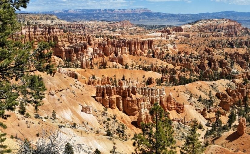
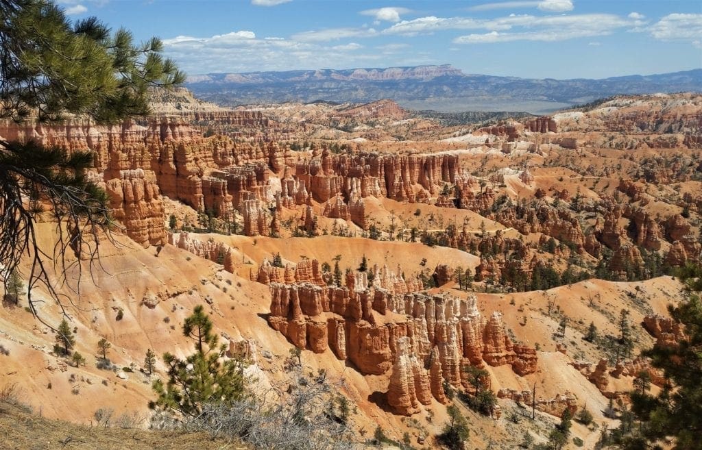
I’d seen the rock formations called “hoodoos” at other parks in the American Southwest, but never so many clustered so close together.
And never with such spectacular views of the vivid red, orange, and white rock towers within such easy access to park visitors.
You don’t have to hike for miles to see the hoodoos – which is great news for families with smaller kids or people short on time.
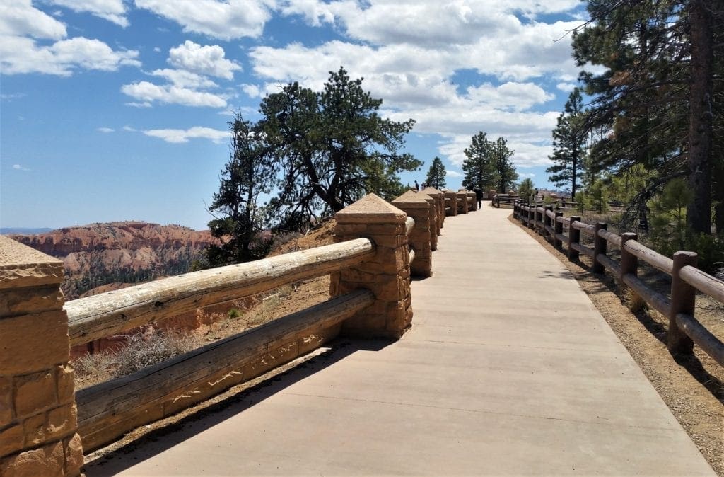
The most spectacular views into the canyon are literally just steps away when you pull into the Visitor’s Center parking lot.
Bryce Canyon National Park was a good stopping place on our springtime tour of southern Utah, and a place we were excited to visit!
Bryce is just a short, hour-and-a-half drive northeast of Zion National Park, so it would be an easy drive to get to our lodgings there at the end of the day.
In a perfect world we would have had a longer stop, but Bryce is on the smaller side for National Parks, so we were able to hit the highlights.
I literally couldn’t stop taking photos, because it was so beautiful – and I’ve included probably way too many of them here 🙂
Our half-day in Bryce Canyon was enough time for a 3-mile hike and stops at the most popular view points.
Here’s what we did, and info about some other trails and park attractions we’ll see on our next visit – maybe you’ll get some ideas for your visit, too.
Some of my posts contain affiliate links. If you make a purchase through an affiliate link, I will receive a small payment at no additional cost to you. As an Amazon Associate, and other marketing affiliations, I earn from qualifying purchases. See full Disclosure page here.
Leaving Moab, we crossed the desert pretty quickly by going West along Hwy 70, then went South on 89 to get to Bryce Canyon .
We hit the road early so we’d have the afternoon free to explore Bryce Canyon.
Going this way, Bryce was on a pretty straight line between Arches National Park (near Moab, Utah) and our evening lodgings inside Zion.
What Makes Bryce Canyon So Special?
Bryce Canyon National Park is much smaller than nearby Zion National Park.
That said, Bryce Canyon still encompasses 35,835 acres and though it does have fewer visitors than Zion National Park or Grand Canyon National Park, it’s probably due in part to Bryce’s more remote location.
The rim at Bryce varies from 8,000 to just over 9,000 feet high. Rainbow Point, located at the end of the park’s 18-mile scenic drive, is the highest part of the park at 9,105 feet.
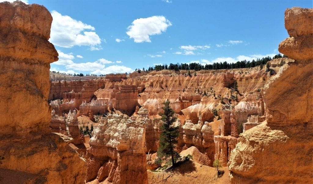
The major feature of the park is Bryce Canyon, which is actually not a canyon at all, but a collection of giant natural amphitheaters.
This makes Bryce Canyon very different from the Grand Canyon and many others which were created by erosion from river waters.
Instead, headward erosion created Bryce Canyon National Park, widening the canyon by erosion along its very top edge, excavating large amphitheater-shaped features in the Cenozoic-aged rocks of the Paunsaugunt Plateau, which is the basis of the park’s geology.
This series of amphitheaters extends for more than 20 miles north-to-south within the park.
The largest is Bryce Amphitheater, which is 12 miles long, 3 miles wide and 800 feet deep.
What is a Hoodoo?
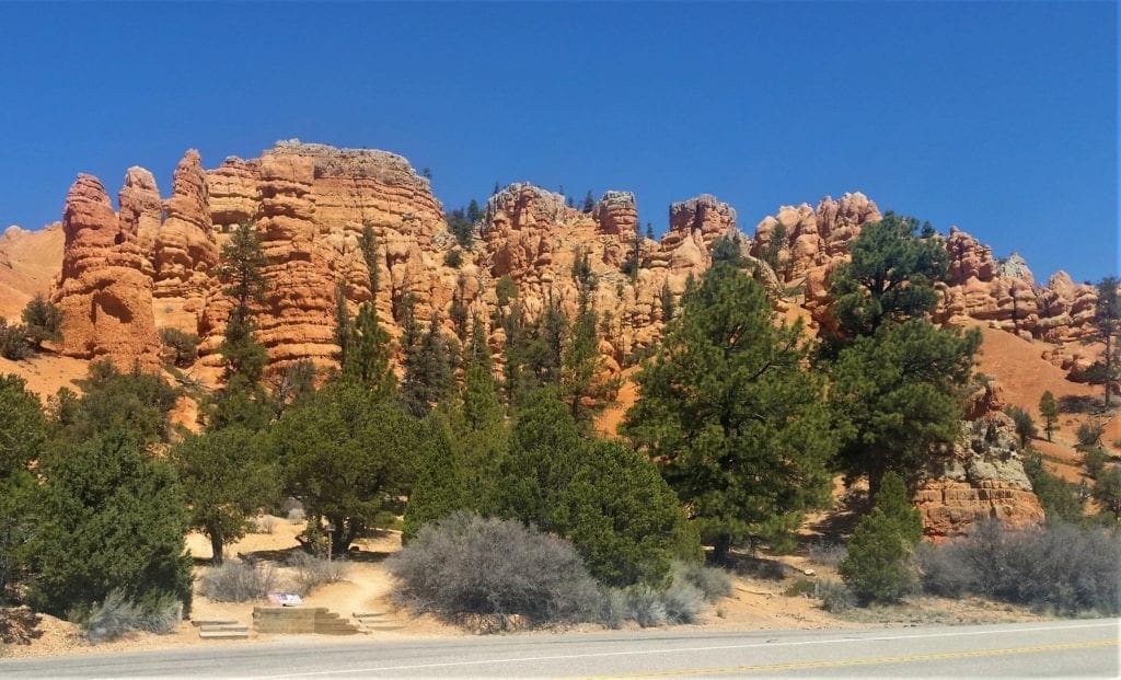
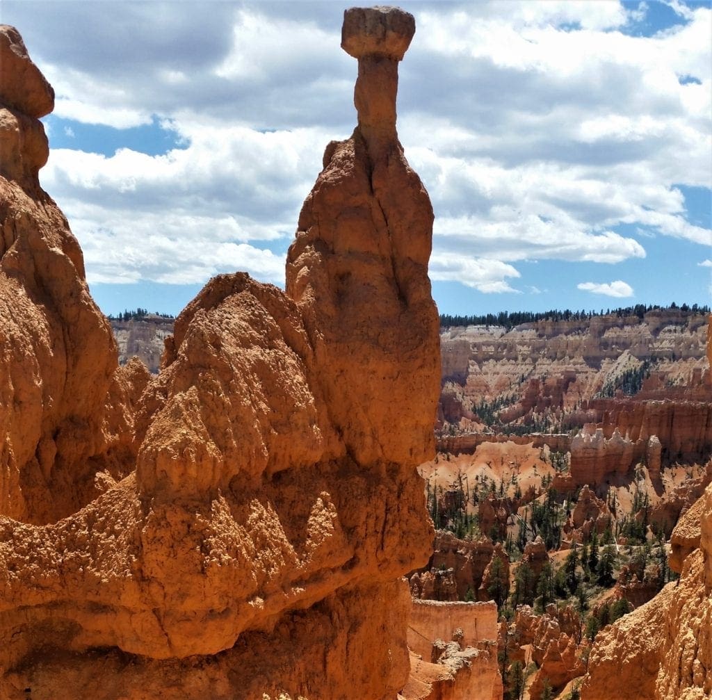
This headward erosion also exposed a multitude of delicate and colorful pinnacles called “hoodoos” that can be up to 200 feet high.
So, what does the word hoodoo mean?
“Hoodoo” can be defined as a combination of voodoo and folk magic, and also as a tall, thin spire of rock that protrudes from the bottom of an arid drainage basin.
In Bryce Canyon, overflowing with hoodoos, both the magic and the stone pinnacles are plain to see.
Geologically, hoodoos are found all around the world, but nowhere on Earth do they occur in such abundance as in Bryce Canyon.
How Are Hoodoos Made?
Hoodoos are composed of soft sedimentary rock and are topped by a piece of harder, less easily eroded stone that protects the column from the elements.
The formations exposed in the Bryce Canyon are the youngest part of the Grand Staircase – an immense sequence of sedimentary rock layers stretching across the southwest portion of North America.

The oldest members of this super-sequence of rock units are exposed in the Grand Canyon, and the intermediate ones can be seen in Zion National Park. (There’s a small amount of overlap in each park.)
More Geology Than You Want To Know
WARNING: Really geeky stuff about rocks below.
The Bryce Canyon area foundations were laid down in a time period that spans the last part of the Cretaceous period and the first half of the Cenozoic era.
The Claron Formation, from which the park’s colorful and delicate hoodoos are carved, began as sediments from cool streams and lakes that existed from 63 to about 40 million years ago (from the Paleocene to the Eocene epochs).
Different sediment types were laid down as the shoreline and river deltas migrated.
The Colorado Plateaus were uplifted 16 million years ago and were segmented into different plateaus, separated from other by faults.
This uplift created vertical joints, which eroded at different rates over time.
The soft Pink Cliffs of the Claron Formation eroded to form the freestanding pinnacles we call hoodoos.
Despite it’s remote location, magical views of the thousands of hoodoos in Bryce attract more visitors every year.
(END of geeky rock stuff.)
In 2018, Bryce Canyon had more than 2.6M visitors – which was an increase of more than 100K visitors from the prior year.
BEFORE THE PARK
The hoodoos have been in the park for literally millions of years, but humans showed up pretty early on, too. Archaeological surveys of Bryce Canyon National Park show that people have been in the area for at least 10,000 years.
Early Inhabitants
Basketmaker Anasazi artifacts several thousand years old have been found south of the park.
Other artifacts from the Pueblo-period Anasazi and the Fremont culture (up to the mid-12th century) have also been found.
The Paiute Indians moved into the surrounding valleys and plateaus in the area around the same time that the other cultures left.
The Paiute in the area developed a mythology surrounding the hoodoos (pinnacles) in Bryce Canyon.
They believed that hoodoos were the Legend People whom the trickster Coyote turned to stone because they were too greedy, and were hogging all of the pine nuts.
The Paiutes referred to the hoodoos as Anka-ku-was-a-wits, which is Paiute for “red painted faces”.
Early American Settlements
It was not until the late 18th and the early 19th century that the first European Americans explored this remote and hard-to-reach area.
The first major scientific expedition to the area was led by U.S. Army Major John Wesley Powell in 1872. Powell, along with a team of mapmakers and geologists, surveyed the Sevier and Virgin River area as part of a larger survey of the Colorado Plateaus, and kept many of the Paiute place names.
In 1873, the Kanarra Cattle Company started to use the area for cattle grazing.
Small groups of Mormon pioneers followed and attempted to settle east of Bryce Canyon along the Paria River.
The church sent Scottish immigrant Ebenezer Bryce and his wife Mary to settle land in the Paria Valley because they thought his carpentry skills would be useful in the area.
The Bryce family chose to live right below Bryce Amphitheater—the main collection of hoodoos in the park.
Bryce grazed his cattle inside today’s park borders, and thought that the amphitheaters were a “helluva place to lose a cow.”
He also built a road to the plateau to gather firewood and timber, and a canal to irrigate his crops and water his animals.
Other settlers started referring to it as “Bryce’s canyon”, which was later formalized into Bryce Canyon.
A combination of drought, overgrazing and flooding eventually drove away the remaining Paiutes. The settlers attempted to construct a water diversion channel from the Sevier River drainage to fight the drought.
When that effort failed, most of the settlers, including the Bryce family, left the area.
Park History
The public first heard about the Bryce Canyon area in magazine articles published by Union Pacific and Santa Fe railroads in 1916, and by 1918 nationally distributed articles also helped to spark interest.
Though poor access to the area and the lack of places to stay kept visitors to a minimum, the number of visitors steadily increased.
So much so that by the early 1920s the Union Pacific Railroad became interested in expanding rail service into southwestern Utah to accommodate more tourists.
At the same time, a movement to have the area protected began, and the National Park Service proposed that Bryce Canyon be made into a state park.
But the governor of Utah wanted national protection of the area.
So, on June 8, 1923, based on the recommendation of the National Park Service, President Warren G. Harding declared Bryce Canyon a national monument.
Congress re-designated the area around Bryce Canyon as a National Park on February 25, 1928.
Other notable dates:
-
- A road was built the same year on the plateau to provide easy access to outlooks over the amphitheaters.
- From 1924 to 1925, Bryce Canyon Lodge was built from local timber and stone.
- Rim Road, the scenic drive that is still used today, was completed in 1934 by the Civilian Conservation Corps.
- Administration of the park was conducted from neighboring Zion National Park until 1956, when Bryce Canyon’s first superintendent started work
- The USS Bryce Canyon, which was named for the park, served as a supply and repair ship in the U.S. Pacific Fleet from September 15, 1950, to June 30, 1981.
- Bryce Canyon Natural History Association (BCNHA) was established in 1961. It runs the bookstore inside the park visitor center and is a non-profit organization created to aid the Park.
- The National Park Service implemented a voluntary, summer-only, in-park shuttle system in June 2000. In 2004, reconstruction began on the aging and inadequate road system in the park.
Your Visit to Bryce Canyon
Before you get to the Park, you’ll drive through Bryce Canyon City, then enter the park and get to the Visitor Center and Bryce Amphitheater parking lot.
This is the main concentration of view points and trailheads, and is also where the lodge and the campgrounds are.
A spur road off to the west goes to Bryce Point.
The main road continues about 18 miles (about a 40-minute drive) to Rainbow Point, with many lookouts along the way.
Visitors Center
If you arrive in Bryce Canyon after 8am, make the Visitors Center your first stop. You can pick up a free park map, talk with the park rangers, and shop for souvenirs.
Note: the Visitor Center doesn’t open until 8 am, but if you arrive earlier, you can walk some of the trails before they get crowded.
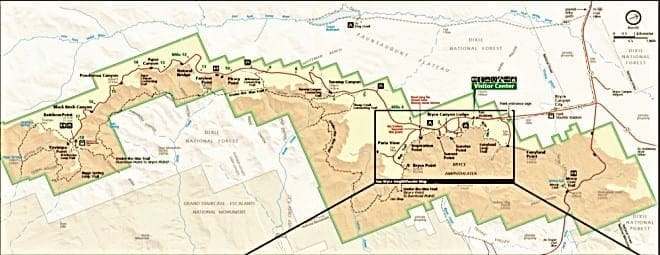
Explore the park map to get an overview of the park’s layout.
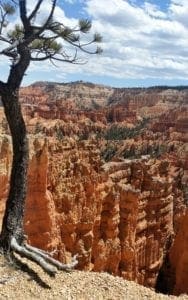
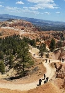
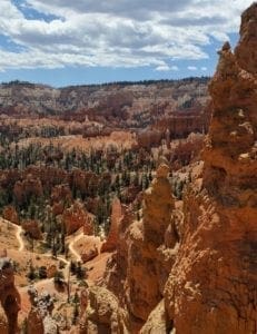
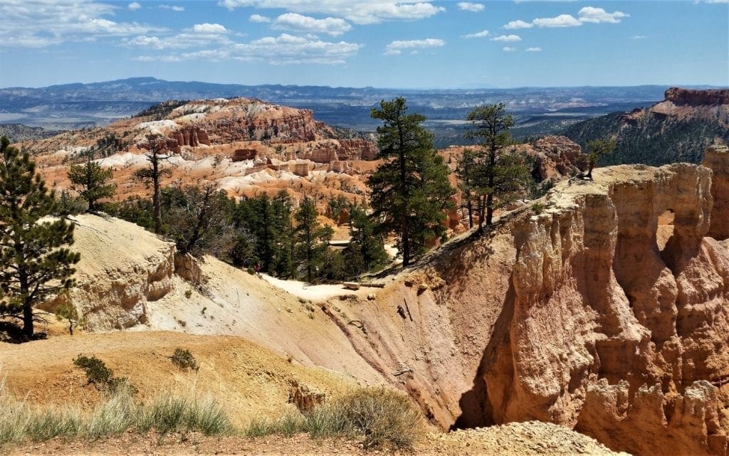
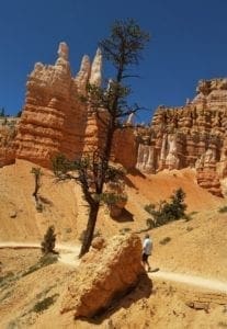
Seeing the Bryce Canyon National Park hoodoos is truly awe-inspiring and every park visitor will spend time at its four main viewpoints, all found within the first few miles of the park: Bryce Point, Inspiration Point, Sunset Point, and Sunrise Point.
That said, I think hiking on trails among the hoodoos is the best way to experience the park.
While the views from the rim of the canyon are amazing, you really appreciate the size and beauty of the hoodoos when you walk among them.
The trails explore the forests of the plateau, connect between viewpoints along the rim of the Bryce Amphitheater, and wander through the hoodoos below.
There are several Bryce hikes you can do in an afternoon.
The Hikes
Bryce is filled with short, incredibly scenic trails. The most popular trail is the Queens Garden Trail, but there are several other great trails to explore as well.
We started with the Queen’s Garden trail, and added on the Navajo Loop.
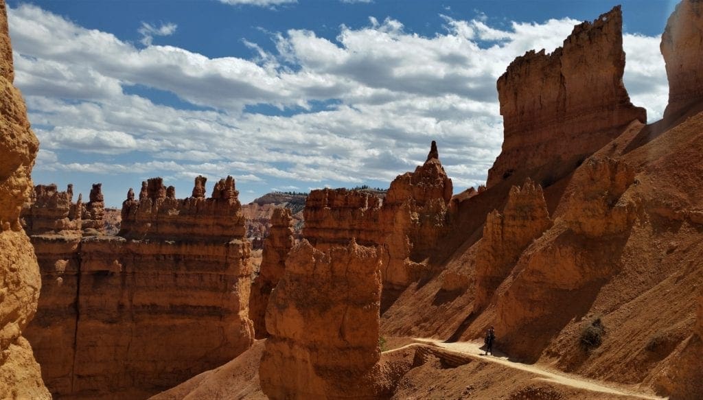
This is the most popular day hike in Bryce Canyon.
The Queens Garden/ Navajo Loop is 2.9 miles long and takes about 2-3 hours on average. It’s a moderate difficulty level, but if you to stop to take photos along the way, it’s less strenuous 🙂
The National Park Service recommends doing it in a clockwise direction because it’s safer and the views are better from that direction.
This is what we did, and the return was admittedly very steep, but I would recommend it anyway.
Start at Sunrise Point and take the Queen’s Garden Trail.
Queens Garden Trail
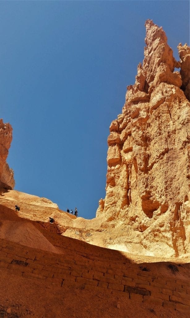
The Queens Garden Trail descends into a “garden” of hoodoos and rock formations. It’s a gorgeous, easy walk for all ages and ability levels.
This is an out and back trail, and the easiest of the trails (moderate level) that go down into Bryce Amphitheater.
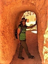
The trail is 0.9 miles each way (1.8 miles round trip) with an elevation change of 357 feet. It should take about 1-2 hours.
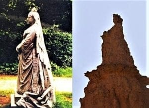
The trail goes from Sunrise Point to the Queen Victoria hoodoo in Queen’s Garden. Along the way you’ll pass through two tunnel archways.
The hoodoo is named after a statue of Queen Victoria, but we had trouble even finding the rock with the alleged resemblance to the monarch.
We did finally figure out which one it was supposed to be. (You can judge for yourself in the photo below.)
After walking the Queens Garden Trail, you can turn around and retrace your steps back to Sunrise Point OR at the end of the Queens Garden Trail, you can follow signs to the Navajo Loop Trail – which is what we did.
Retrace your steps back to the fork and then follow the signs to the Navajo Loop Trail.
This valley trail is 0.7 miles long and connects the Queens Garden Trail with the Navajo Loop Trail. Most of this easy flat trail is through pine forests.
Back on the main trail, continue another 0.8 miles to a 4-way junction. From here, take the Navajo Loop trail, and there are two choices back up to the rim for which side of the loop you go to get to Sunset Point.
You can go via Two Bridges (0.6 miles) or via Wall Street (0.7 miles). NOTE: The Wall Street section is only open in summer.
Navajo Loop Trail
Another of the favorite hikes in Bryce Canyon, this Navajo Loop Trail is a moderate 1.3 mile hike with an elevation change of 550 feet.
The Navajo Loop Trail makes a loop, starting and ending at Sunset Point. It takes 1-2 hours. (The Wall Street section is closed in winter, so the whole loop is only possible in summer.)
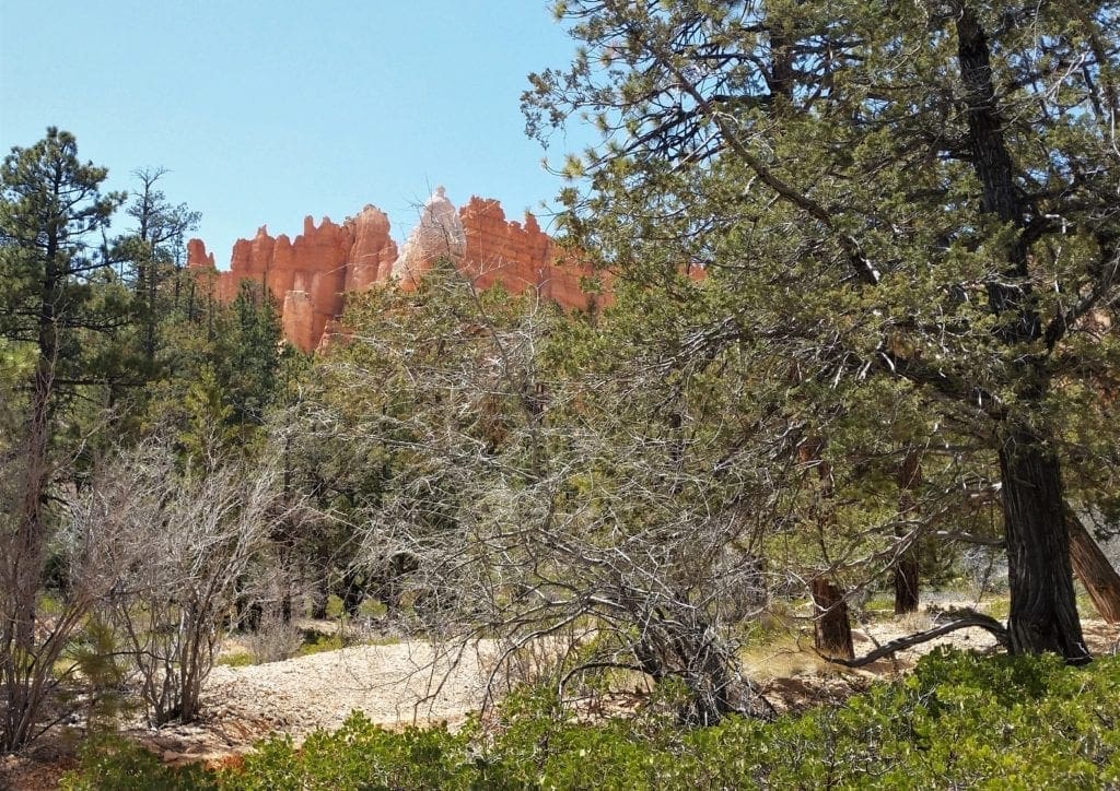
This part of the trail takes you through a forest, so it’s a very different landscape than the hoodoos.
We took the Two Bridges because Wall Street was closed, but there are also better views of Thor’s Hammer and some of the other more famous hoodoos that you don’t see as well in the Wall Street section.
The trail ends either way at a series of really steep switchbacks and ascends back up to the rim.
Then it’s an easy 0.5 miles along the rim from Sunset Point to Sunrise Point to finish the loop.
Sunset Point to Sunrise Point Trail
This is the easiest trail and is one of the best hikes in Bryce Canyon, even though it doesn’t go down in among the hoodoos.
It is a 1 mile round trip (0.5 miles one way) of paved path with just a 34-feet elevation change. It takes about an hour and is wheelchair accessible.
Rim Trail Bryce Canyon
The Rim Trail in Bryce Canyon goes all the way from Bryce Point to Fairyland Point, and can be broken into sections connecting the best views of the hoodoos from the rim.
We did all of the sections except the one to Fairyland Point, due to time constraints.
- Bryce Point – Inspiration Point: 1.5 miles; closed in winter. Bryce Point has arguably the best views of the main amphitheater.
- Inspiration Point – Sunset Point: 0.7 miles. The view from Inspiration Point is similar to Bryce Point, but the hoodoos are closer, so you can see more details.
- Sunset Point – Sunrise Point: 0.5 miles. This section is paved.
- Sunrise Point – Fairyland Point: 2.4 miles
If You Have More Time
We didn’t do these next hikes, but would have, given more time.
Maybe you’d like to try them out:
Rainbow Point and Yovimpa Point
Located as far south as you can drive in Bryce. It’s a good view, but not as good as Inspiration Point or the views from the Rim Trail.
To get there, it takes about 20 minutes of driving from Bryce Point. On the way, you can also stop at Natural Bridge.
Peekaboo Loop Trail
The Peekaboo Loop Trail is a 4.8 mile trail through a valley filled with colorful hoodoos.
The hike starts at Bryce Point, and descends 1 mile down into the valley, does a 3 mile loop through the hoodoos, and then climbs the last mile back up to Bryce Point.
Fairyland Loop Trail
This is the longest hike on this list. It’s an 8 mile hike, starting and ending at Fairyland Point in the northern part of Bryce.
This hike is rated as strenuous because of its length and elevation changes. If you want to get away from crowds, this is your hike!
Park Info
Below is some general info you’ll find useful when planning your trip.
Bryce Canyon Weather
Park Wildlife
The forests and meadows of Bryce Canyon support an abundance of animal life including foxes, badgers, porcupines, elk, black bears, bobcats, and woodpeckers. Mule deer are the most common large mammals in the park.
Bryce Canyon National Park forms part of the habitat of three wildlife species that are listed under the Endangered Species Act: the Utah prairie dog, the California condor, and the southwestern willow flycatcher.
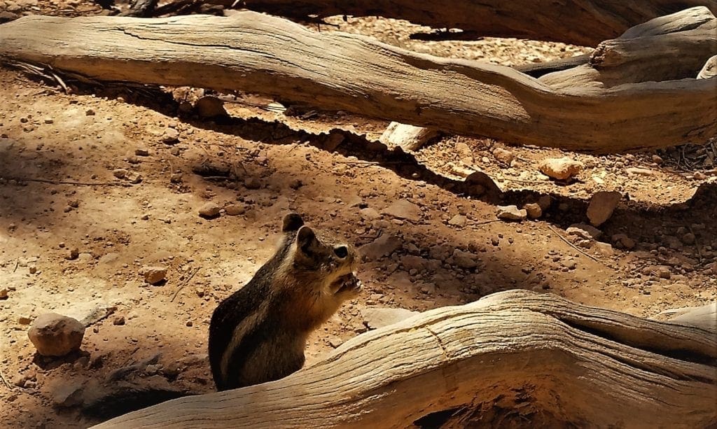
That said, during my Springtime visit, the only wildlife I saw (other than the occasional bird overhead) was this busy little chipmunk.
Stargazing
Bryce Canyon has a 7.4 magnitude night sky, making it one of the darkest in North America.
Stargazers can see 7,500 stars with the naked eye – the light pollution in most places reduces visibility to less than 2,000 stars. In large cities, you’re lucky to see more than a few dozen.
Park rangers host public stargazing events and evening programs on astronomy, nocturnal animals, and night sky protection.
Deepen your understanding of the park by attending an astronomy program, or full moon hike.
Where to Stay
Bryce Canyon City is definitely not a city – but it is an area with accommodations and restaurants for travelers visiting Bryce Canyon. It’s about three miles from the park – the closest lodging outside the park.
Bryce Canyon offers two campground sites (one in winter) and lodging is available at the Bryce Canyon Lodge during the summer season. During winter, hotel rooms are available in the park at the Sunset Hotel.
Park Shuttle
You can drive through most of the park, but the main area gets very crowded and parking is scarce. If you’re staying in this area, the shuttle bus is your best bet.
The shuttle is free with your national park admission (which is $35 – or free with your annual pass).
The shuttle runs every 15 minutes. The whole route takes less than an hour.
Shuttle Schedule 2019:
| April 11 – May 9 | 8:00 AM to 6:00 PM |
| May 10 – September 29 | 8:00 AM to 8:00 PM |
| September 30 – October 20 | 8:00 AM to 6:00 PM |
There is no shuttle October 21-April 10.
Park Location and Hours
Park Physical Address:
Bryce Canyon National Park
UT-63
Bryce, Utah 84764
Phone: (435) 834-5322
Open Hours:
Visitor Center Operating Hours:
| Summer | May – Sept | 8:00 a.m. – 8:00 p.m. |
| Fall | October | 8:00 a.m. – 6:00 p.m. |
| Winter | Nov – March | 8:00 a.m. – 4:30 p.m. |
| Spring | April | 8:00 a.m. – 6:00 p.m. |
Leave a comment about your visit to Bryce Canyon, or if you have a question drop me an email and I’ll reply as soon as I can.
For more posts with ideas for places to go hiking, go to the Hiking Destinations page.
Thanks for stopping by – see you next time! LJ
To Get New Idratherwalk Posts
sent directly to your inbox (how convenient!) Click this Button
If you enjoyed this post, please share it:

LJ has spent much of her free time as a single Mom – and now as an empty-nester – hiking in the US and around the world. She shares lessons learned from adventures both local and in exotic locations, and tips on how to be active with asthma, plus travel, gear, and hike planning advice for parents hiking with kids and beginners of all ages. Read more on the About page.