Most recently updated January 16th, 2022
I first heard about Palo Duro Canyon State Park a couple of years ago. It was February, and I wanted a good place to hike for a few days that was out of the cold, but not out of the USA.
A couple of hiker friends recommended Palo Duro Canyon, known as the “Grand Canyon of Texas”.
After doing a some follow-up research, I decided that the park sounded perfect for my short solo hiking trip.
I booked a flight, bought some new boots, and went on down to Texas to see it for myself.
About Palo Duro Canyon State Park
Palo Duro Canyon State Park, the second largest canyon in the country, lies in the heart of the Texas Panhandle.
The canyon is on the southern high plains, known as El Llano Estacado or the Staked Plains. The rim of the canyon is part of the shortgrass prairie.
Extending from Canyon all the way to Silverton, the canyon is about 120 miles long and 20 miles wide, and is up to 800 feet deep.
Though Palo Duro Canyon is less than half the size of the Grand Canyon, it still offers great opportunities for the whole family for hiking, biking, horse-riding, and camping.
Some of my posts contain affiliate links. If you make a purchase through an affiliate link, I will receive a small payment at no additional cost to you. I do not get paid for recommendations, all opinions on this site are my own. See full Disclosure page here.
Park Location
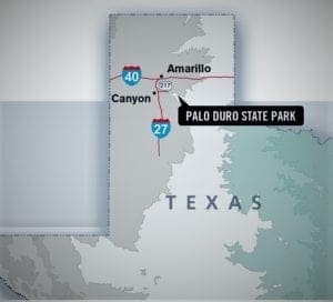
The park is less than an hour’s drive from Amarillo. I flew in from Raleigh to the Amarillo airport, and drove a rental car from there.
To reach the park From Amarillo, take Interstate 27 south to State Highway 217, and go east eight miles.
The park is located about 12 miles east of the city of Canyon on State Highway 217. There is only one road in the Palo Duro Canyon State Park: Park Road 5. This road begins at the park entrance and makes a lollipop loop from there.
(If you’re interested in an amazing family outdoor adventure, but need something closer to the East coast, check out this post about the Flume Gorge. )
Where To Stay
You could stay in Amarillo (which hosts a variety of hotel options), or in Canyon or in the park itself.
I stayed at a chain hotel in Canyon, about a ten minute drive from Palo Duro. The benefit of that was a shorter drive, less gear to haul around, free breakfast, and all the comforts after a long day of hiking.
Inside the park, you can choose from campsites with water and electricity, primitive drive-up sites, equestrian sites, or backpack camping areas.
There are also three cabins on the canyon’s rim or four limited service cabins on the canyon floor.
You can reserve tent sites in Palo Duro for only $12/night plus the $8 daily entrance fee. Arrangements can be made at the Visitor’s Center or online.
History of the Canyon
It’s believed early Spanish explorers discovered the canyon and named it “Palo Duro” (or “Hard Wood”) because of the large number of juniper trees growing in the canyon bed.
The canyon was formed when the Prairie Dog Town Fork of the Red River began carving its way through the southern High Plains.
The rocks layers visible today tell a geologic story that began roughly 250 million years ago.
The canyon itself began to form a million years ago.
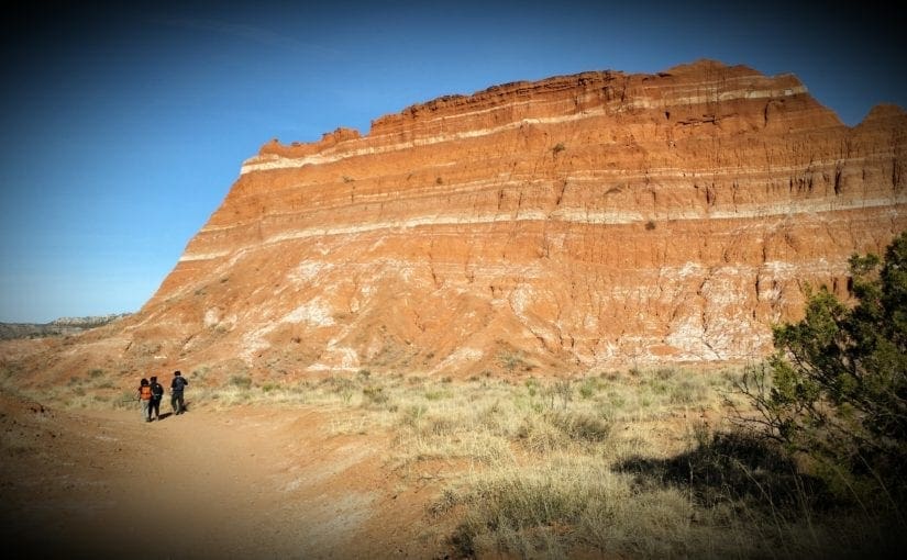
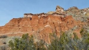
The Rock Layers
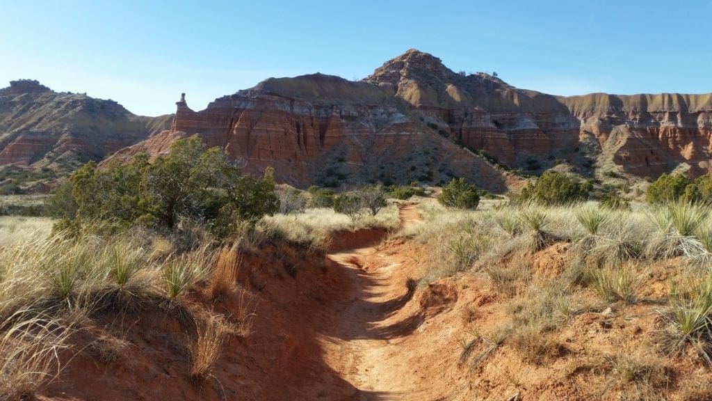
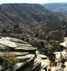
You can easily see the vibrant colors of the rock layers transition as you descend 500 feet to the floor of the canyon.
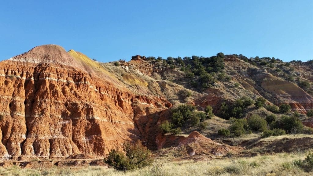
- Cloud Chief gypsum, the oldest layer of rock visible in the canyon, is seen in a few areas closest to the canyon floor.
- The next oldest layer, and usually the most visible, is the Quartermaster Formation. This layer consists of distinctive red claystone/sandstone and white ribbons of gypsum.
- Above the Quartermaster Formation you’ll see the Tecovas Formation with its yellow, gray and lavender mudstone and sandstone layers.
- Above the Tecovas Formation are the Trujillo and Ogallala formations. The Trujillo is made up of sandstone and shale, and the Ogallala consists of sand, clay, silt and limestone and makes up distinctive hard caprock.
Hoodoos
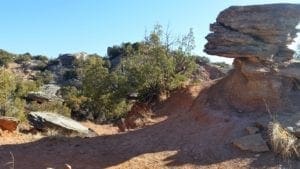
Rock formations with a larger rock balanced atop a smaller base are called “Hoodoos”. Hoodoos are created when harder rock on top protects a softer rock underneath, and the rock layers erode at different rates.
People Of the Canyon
People have inhabited Palo Duro Canyon for about 12,000 years.
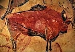
The Clovis and Folsom peoples first lived in the canyon and hunted large herds of mammoth and giant bison.
Other cultures, such as the Apache, Comanche and Kiowa, inhabited the area more recently.
Battle of Palo Duro
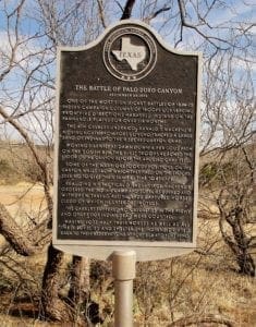
Native Americans left the Panhandle plains following a decisive battle in the canyon on Sept. 28, 1874.
The battle took place during the Red River War between the U.S. Army and southern Plains Indians, which lasted from June 1874 to spring 1875.
LONGHORN RancherS
In 1876, Charles Goodnight, a former Texas Ranger, drove 1,600 Longhorn cattle to the canyon. He and his partner John Adair, an English aristocrat, founded the JA Ranch in 1877.
At its peak in 1885, the ranch grazed 100,000 head of cattle on 1,325,000 acres spread across the Panhandle.
Just a couple of years later, in 1887, Goodnight decided to scale back his ranching activities and the partners divided the land.
Most of the canyon still belonged to the JA Ranch until 1890. Adair descendants continue to run the remaining JA Ranch lands to this day.
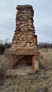
Building A State Park
The state bought the land for the park from Fred S. Emory in 1933.
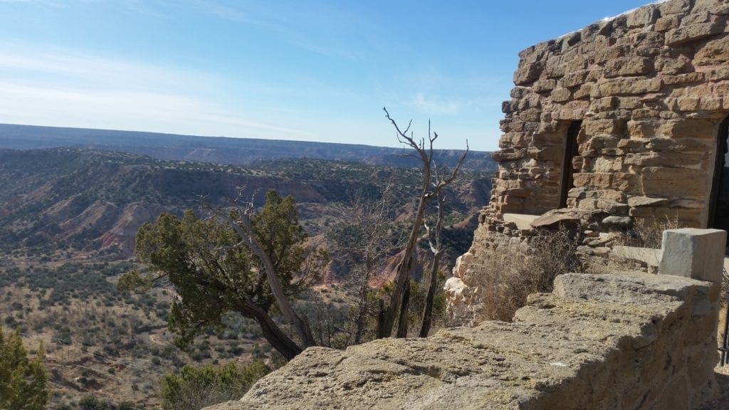
Soon after, Civilian Conservation Corps (CCC) workers arrived, and spent the next five years creating a park.
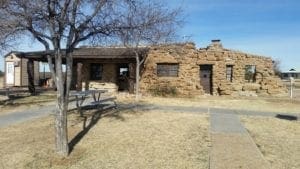
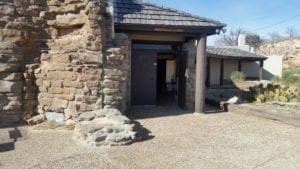
CCC workers made all of the park’s original improvements, including El Coronado Lodge (now the Visitor Center), the cabins on the rim and canyon floor, and trails.
Local stone and wood were used for building materials. CCC workers also forged decorative metal and hand-crafted furniture.
Palo Duro opened in 1934 before it was fully completes. It’s still the second largest park in the state parks system, with a land area encompassing about 28,000 acres.
Civilian Conservation Corps
President Franklin D. Roosevelt created the Civilian Conservation Corps in 1933, during the Great Depression. The CCC program enrolled men between the ages of 17 and 25 who qualified for public assistance to work on conservation projects. They earned clothing, food, medical care and $30 a month and lived on site. Most of the men sent the money home to their families.
You can learn more about how the CCC built Palo Duro Canyon State Park more on the park website’s History page.
Animals in the Canyon
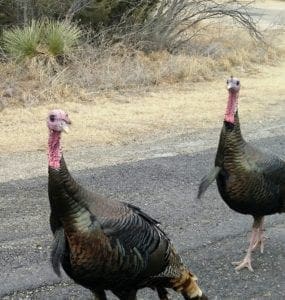
Palo Duro hosts lots of wildlife including wild turkeys, many species of birds, rabbits, white-tailed and mule deer, coyotes, bobcats, road runners, and many types of snakes and lizards.
Endangered Species
Two threatened species live here: the Palo Duro mouse and the Texas horned lizard.
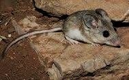
The Palo Duro mouse lives in only three Texas counties, with the largest populations in Palo Duro Canyon and Caprock Canyon state parks.
The mouse is about 8 inches long – if you include its 4-inch tail. Palo Duro mice live in canyon walls, which keeps them safe from predators.
Texas Longhorns
In 1493, the Spanish explorers brought the first long-horned cattle to the new world; many of them escaped into the wild.
Their descendants, known as longhorns, roamed Texas for 200 years.
Early settlers rounded up the longhorns, prizing them because they were hardy and could survive on poor pastureland. The Texas Longhorn developed from this hybrid.
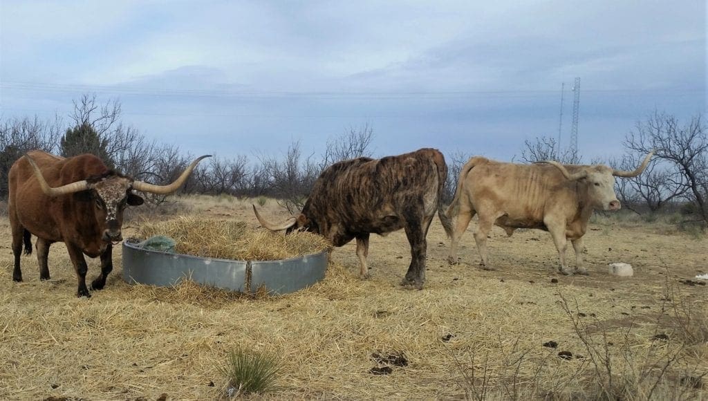
Noted for longevity, Texas Longhorns may live longer than 30 years and produce calves past the age of 20. Bulls are known for their massive horns – which may spread up to 6 feet from tip to tip.
Charles Goodnight, co-founder of the JA Ranch, said, “As trail cattle, their equal has never been known… No animal of the cow kind will shift and take care of itself under all conditions as will the Longhorns.”
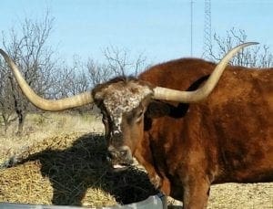
Several members of the official State Longhorn Herd live at the park. Look for them on the rim, or near the park entry.
I was lucky enough to meet T-Bone, Brisket, and Omelette as they were feeding on my way out of the park in the late afternoon.
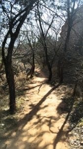
Hiking at Palo Duro Canyon
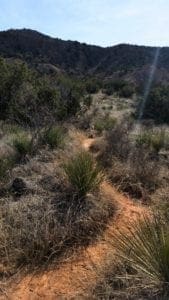
There are more than 30 miles of hiking, biking and equestrian trails. You can explore the canyon by foot, mountain bike, horse or car.
I was there to hike, so except for my first drive around the park to orient myself, I opted to explore on foot.
The park has a wonderful detailed map of the trails that they give to you on your way in after you pay the entry fee.
PALO DURO CANYON Weather
Generally, I found the hiking to be very easy – even the trails indicated as “difficult”- but I am a fit experienced hiker. That said, the trails shouldn’t be too hard for anyone – even grade-school children (on shorter hikes) – if they’re reasonably fit with the proper hiking gear.
I visited in February, so the high temps were only in the 60-70s, but in the summertime (as for all hiking in the Southwest) it can be extremely hot and dry.
You’ll definitely need to pack a hat, sunglasses, sunscreen, and lots of water no matter what time of year you visit.
Summertime is the busiest time, and the park is overflowing with families during the school holidays. I had planned my trip for the “shoulder season”, so it was very quiet when I was there, and some of the facilities were on shorter hours or closed for the winter season.
Stop by the Visitor Center on the canyon rim to learn more about the park in general, and also if there are any trail or facility closures. You can also purchase passes or camping permits.
The park store at the Visitor Center sells books, pottery, jewelry and more. For souvenirs, snacks and meals stop by The Trading Post on the canyon floor.
The Trails
I arrived in the afternoon on my first day in town, so I used that day to figure out how to get to the park, get the trail map, do a general drive around for orientation.
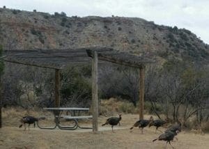
I followed the park road around, and was a little alarmed when I was surrounded by a flock of wild turkeys in an RV camp. (I think they wanted cheese crackers.)
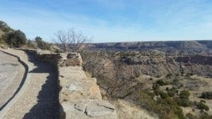
I also poked my head in to look around the Visitor’s Center before taking the short walk around the nearby CCC Overlook to get a look at the canyon before dark.
At sunset, I went back to town to get some dinner and plan my hikes. I only had three full days to spend in the park, and I wanted to make the most of them!
The Lighthouse Trail
RATED: Moderate. 2.72mi (One Way).
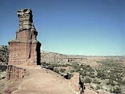
The Lighthouse Trail at Palo Duro Canyon State Park is the park’s most well-known trail, so it was a must-do for me.
The Lighthouse Trail is the most popular trail in Palo Duro because it reaches a large red outcropping that looks like – you guessed it – a lighthouse. The trail is multi-use, so hikers, bikers, and equestrians can all use it to reach the park’s most iconic natural feature.
The Lighthouse rock formation, a designated National Natural Landmark, is 310 feet tall, and can be seen from far across the canyon floor as you hike towards it.
The Lighthouse Trail is 2.7 miles each way (round-trip distance of 5.75 miles) and generally flat and easy, except for a few difficult slippery dirt slopes near the end.
For bikers, the park provides a bike rack where the trail gets steep, about 0.25 miles from the actual Lighthouse, so they can park and hike from there.
For efficiency, I combined the Lighthouse Trail with the Givens, Spicer, and Lowry Trail (3.1 miles) and the Paseo del Rio Trail (1 mile) to create a 6.8 mile loop.
I actually hiked this trail twice – once starting from the GSL trailhead, which was a much narrower less traveled trail, and starting again at the Lighthouse/Paseo del Rio trailhead, because the GSL joins the Lighthouse trail after the first mile.
I wanted to go back if I had time, to see what the Lighthouse Trail was like from the beginning.
I’m glad I did, because it was a very different experience.
The Lighthouse trail is very wide and well-worn red clay trail, that looks like it could actually be a road for ATVs. My guess is that this trail is extremely crowded during the busy season.
I would recommend going the longer combined route with the SGL trail if you have the option, for more natural terrain.
Givens, Spicer, Lowry Trail
RATED: Difficult. 3.08mi (One Way).
The 3.1 mile GSL trail, named after avid runners who helped build the Palo Duro Canyon’s trail system, is a great add-on to the Lighthouse Trail.
As you might expect, the GSL trail is also regularly used for 5k training runs by locals, so it’s a relatively flat and easy walk, provided you bring enough water!
Paseo del Rio Trail
RATED: Easy. 1.03mi (One Way).
There’s nothing very remarkable about this easy 1 mile trail, but it serves as an alternative to walking down the road back to the start of the Lighthouse Trail.
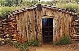
One point of interest is the Cowboy Dugout which is set up to show how cowboys lived in the 1880s.
Rock Garden
RATED: Difficult. 2.39mi (One Way).
This was my favorite hike in the park, though it does have a little bit of an uphill climb.
You’ll go up 600 feet from a field of giant boulders at the bottom of the canyon all the way up to the Rylander Fortress Cliff Trail along the canyon’s rim.
short video of the Rock Garden trail:
I hiked this trail, including a snack break on top of a giant boulder from the ancient landslide, and then continued on to the Rylander Fortress Cliff Trail to the North of the Rock Garden Trail.
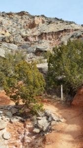
Juniper Riverside Trail
RATED: Moderate. 1.07mi (One Way).
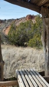
This hike was very flat and easy, and offered stunning views of the colourful cliff formations, especially in the late afternoon light. It was also nice to hike near some water, which was different from the extreme dryness of the rest of the park.
Since the hike was down in the river valley there were a lot of Juniper trees along the trail. There were also beautiful red and white Spanish Skirts rock formations along the edge of the river.
If you’re looking for an easy relatively short hike, this is a good option.
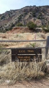
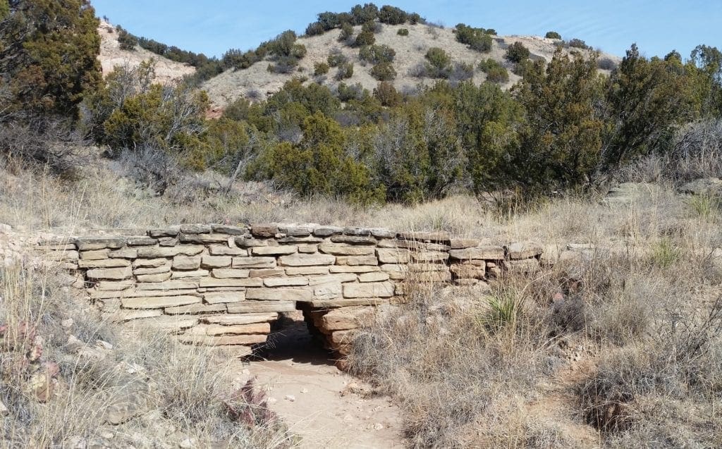
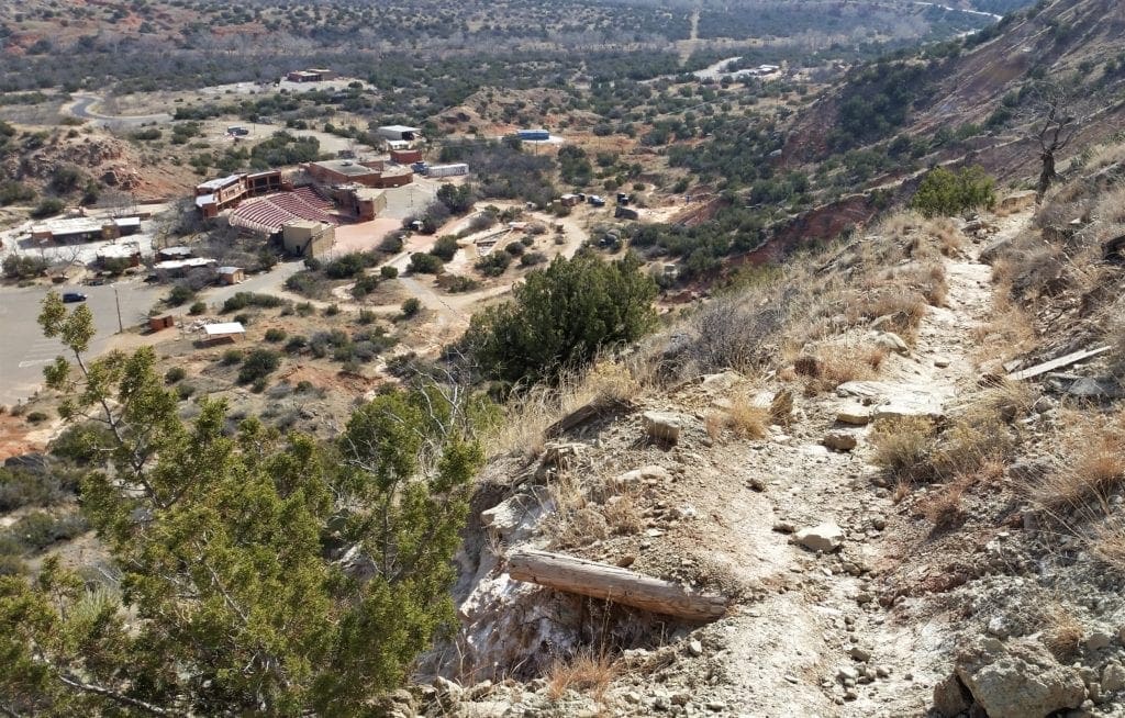
CCC Trail
RATED: Difficult. 1.43mi (one way).
Immediately upon entering the Palo Duro Canyon Park, you’ll see the CCC Overlook, which offers an excellent viewpoint over the canyon below.
From this overlook it is possible to hike the 1.4 mile trail 500 feet down to the park’s amphitheater.
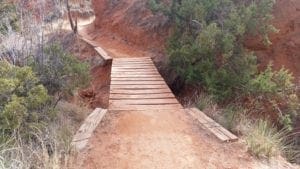
You’ll cross four historic CCC bridges as you descend from the canyon rim (at the overlook) down to the canyon floor.
The only drawback to this trail is that you need to climb back up again 🙂
Rylander Fortress Cliff
RATED: Easy. 3.73mi (one Way).
This was also a great trail, in spite of it’s easy rating. The hike followed along the eastern rim of the canyon, and provided some really fantastic views of the canyon below – and across to the other side!
Be sure to take all of the trail spurs as well, if you have time. Here’s a short video from the cliffs – too windy to hear me, but you get the drift.
see the view from rim to rim:
The Big Cave
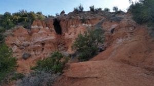
The cave is located near the Juniper Cliffside and Juniper Riverside trails.
It’s a bit of a climb to the mouth of the cave, but a lot of fun to scramble up and poke your head in.
I wouldn’t recommend exploring this area in the rain, though, as it could get slippery and there are some significant crevasses.
The Big Cave was my last visit, before I left the park on my last day – and I’m really glad I had the chance to see it!
How to Get Involved
Volunteer
The park needs you! Visit the Volunteer page and search by zip code (79015) to see how you can help.
Or visit the Partners in Palo Duro Canyon Foundation website to learn about other ways to help.
Ranger Programs
Programs on the park’s history and natural features are available. You can learn about birds or Longhorn cattle, or take a driving tour with a park ranger.
Visit the park’s Events page for upcoming programs.
You can also connect with the park on Facebook and Instagram.
Leave a comment with your own favorite things to do at Palo Duro Canyon!
If you’re looking for some travel pointers or discounts for your next adventure, check out my Travel Resources page.
To read about other State And National Parks I’ve visited, check out my Hiking Destinations page.
Or if you have a question, I’ll reply as soon as I can. Thanks for stopping by – see you next time! LJ
To Get New Idratherwalk Posts
sent directly to your inbox (how convenient!) Click this Button
If you like this post, please share it!

LJ has spent much of her free time as a single Mom – and now as an empty-nester – hiking in the US and around the world. She shares lessons learned from adventures both local and in exotic locations, and tips on how to be active with asthma, plus travel, gear, and hike planning advice for parents hiking with kids and beginners of all ages. Read more on the About page.