Most recently updated January 16th, 2022
The Flume Gorge natural area in New Hampshire’s Franconia Notch State Park is spectacular and pictures just don’t do it justice.
Eight hundred feet long and about 20 feet from side to side at its widest, with granite walls 90 feet high, the Flume feels like you’ve entered a different world or stepped back in time.
It’s something you really have to see for yourself to appreciate.
I returned last week from my second visit (in the past year!) to the area – the first was early last November, and a freak storm had covered the place deep in snow, so I wasn’t able to hike very far.
But my most recent visit, in early May, was perfect weather for visiting the gorge, and well worth the return trip!
I went on my own, but walking the self-guided 2-mile Flume Trail through the Flume Gorge is a great way to spend some time outdoors with the whole family.
Though there are many more difficult hikes in the Franconia Notch area for seasoned hikers, the Flume Trail is an easy manicured walk for hikers of all ages and abilities.
But don’t think you’ll be bored because it’s an easier hike.
In addition to the prehistoric beauty of the gorge, you’ll be splashed by waterfalls and cooled by mist, see huge Ice Age boulders, walk through historic covered bridges, and take in some beautiful mountain views.
Some of my posts contain affiliate links. If you make a purchase through an affiliate link, I will receive a small payment at no additional cost to you. I do not get paid for recommendations, all opinions on this site are my own. See full Disclosure page here.
ABOUT FRANCONIA NOTCH STATE PARK
Franconia Notch State Park, located in the heart of the White Mountain National Forest, was the home of the famous Old Man of the Mountain, the same “Great Stone Face” immortalized in literature by Nathaniel Hawthorne and Daniel Webster.

The park stretches along 8 highway exits, and offers outdoor adventures suitable for everyone in the family.
There are wooded trails that are challenging enough for thru-hikers, but still accessible for more casual day-hikers, families and mountain bikers – with crystal-clear lakes for anglers and kayakers, too.
The nearby town of Lincoln, NH offers a host of small, informal eating places, as well as a winery and a craft brewery – and places to stay outside of the park.
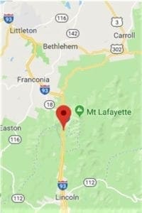
Where is the Flume Gorge?
Flume Gorge is one of the major attractions at Franconia Notch, the winding mountain pass that cuts through the White Mountains in New Hampshire.
The Notch connects the more densely populated southern part of the state with its wilder Northern side (a region locals refer to as “North of the Notches”) via the the Franconia Notch Parkway (Interstate 93 and U.S. Route 3).
The parkway required a special act of Congress to sidestep design standards for the Interstate highway system because it is only one lane in each direction.
The Flume lies at the southern end of the Notch.
(If you’re looking for a place to have a family outdoor adventure, but need something more on the west side of the continent, check out this post about Palo Duro Canyon.)
HOW AUNT JESS DISCOVERED FLUME GORGE
In June 1808, “Aunt” Jess Guernsey, aged 93, set out on foot from her family’s log house at the base of Mount Pemiwegasset to look for a new place to fish.
Following the sounds of water downhill, Jess found herself at the bottom of a chasm carved deep into the granite of the rugged White Mountains, with a roaring stream at its base.
Aunt Jess had discovered the Flume Gorge! (Though I’m guessing that local native people knew about it before then.)
Although she’d lived close to it for years, she’d never seen before
She eventually convinced her family to come and see it for themselves – at first, they didn’t believe her.
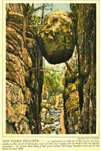
At that time, a huge egg-shaped boulder hung suspended between the walls.
The rock was 10 feet high and 12 feet long.
A heavy rainstorm in June of 1883 started a landslide that swept the boulder from its place.
The boulder has never been found.
That same storm deepened the gorge and also formed Avalanche Falls and widened the stream itself.
GEOLOGY
Today, the Flume Gorge is a natural chasm extending 800 feet at the base of Mount Liberty. The walls of Conway granite rise to a height of 70 to 90 feet and are 12 to 20 feet apart.
During the Jurassic Period (the era roughly 197 to 146 million years ago when dinosaurs roamed the earth) the granite that now forms the canyon’s walls was deeply buried in molten rock.
As it cooled, the rock was broken up by vertical fractures and small dikes of volcanic basalt were forced up alongside them.
Eventually, erosion created horizontal cracks, allowing water to seep into the rock layers. Those basalt dikes eroded faster than the surrounding granite, creating the gorge.
If you look at the floor of the Gorge you might notice remnants of the basalt dikes. The granite and basalt are still being eroded by frost and water.
You’ll also see small trees growing on the walls of the gorge – their roots creating and deepening cracks in the rock.
FLUME GORGE HIKES AND SIGHTS
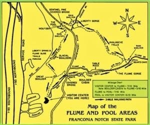
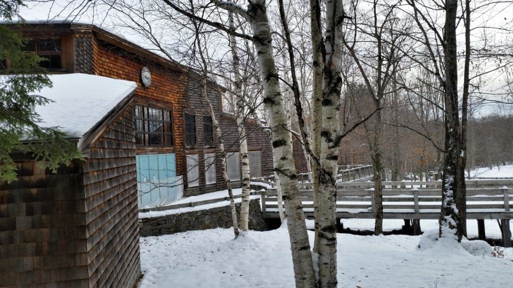
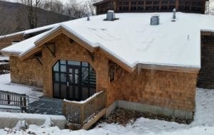
A trip into the Flume Gorge starts at the Flume Visitor’s Center, where you’ll pay your entrance fees and gain access to the trails.
Framed by a spectacular vista of Mount Liberty and Mount Flume, the Flume Gorge Visitor Center is a large, welcoming building with a gift shop, cafeteria and information on the gorge itself and the Notch area.
The building’s vaulted atrium houses the Concord Coach, an ornately filigreed stagecoach built in 1874, that once carried proper Bostonians from the train station in nearby Plymouth to the Flume – which was a major 19th-century tourist attraction.
You can also take a break and view a 20-minute movie showcasing Franconia Notch State Park; the film runs continuously throughout the day.
Step out of the back door of the Visitor’s Center to begin your walk to the Flume.
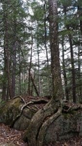
Glacial Boulders
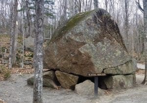
As you walk through the area, you’ll see many large boulders – some weighing over 300 tons.
These are remnants from the glacial period, when a great ice sheet more than a mile thick moved over this area.
As the glaciers receded (about 25,000 years ago), it left these big boulders – called “glacial erratics” – behind, and the Flume Brook began to flow through the valley again.
Throughout the park you’ll notice the birches, yellow beeches and maples, trying to take root in these granite boulders.
Sometimes when the trees’ roots go off in search of soil and nutrients, they create living sculptures on the rocks.
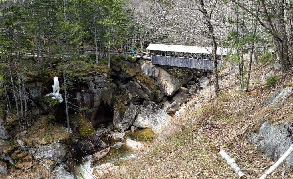
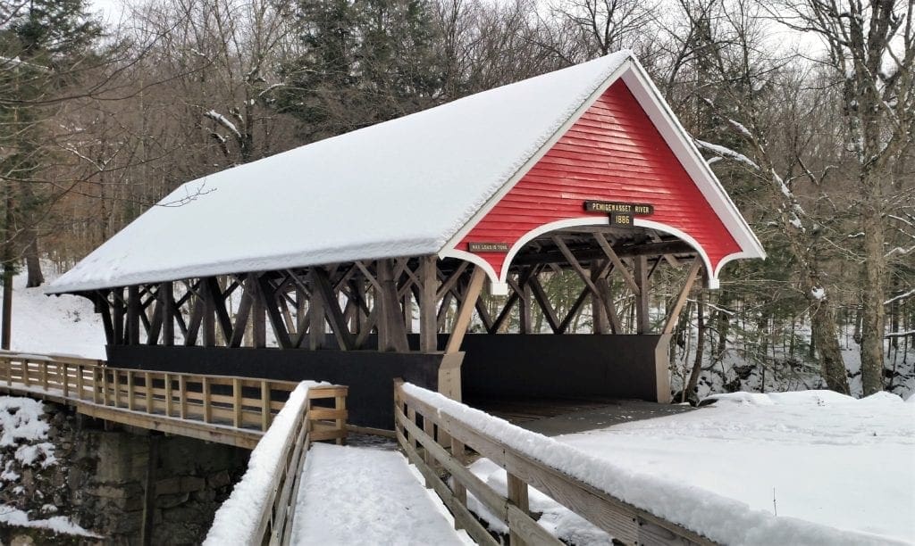
The Flume Covered Bridge
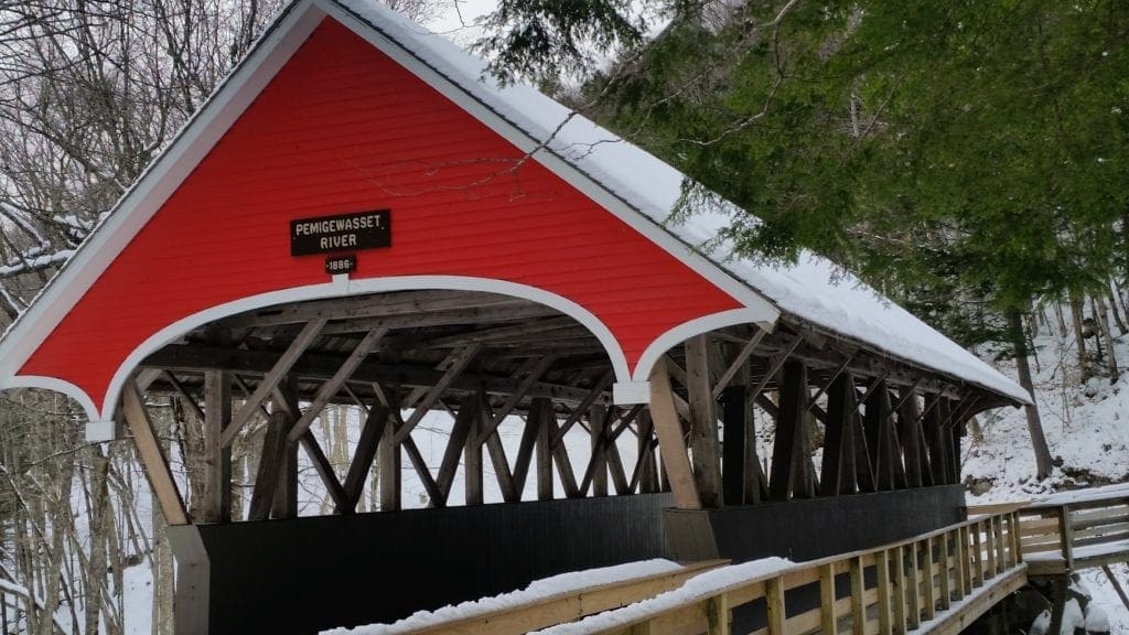
At the base of the gorge, you’ll see the Flume Covered Bridge, the oldest covered bridge in the State. Built in 1886, it spans the Pemigewasset River (which means “swift or rapid current” to the Abenaki Indians) and is open to buses and foot traffic.
The Flume Bridge has been restored (twice) and it’s very picturesque, especially when it’s vibrant red roof stands out in winter snow. This is one of two covered bridges in the gorge.
The Flume Trail continues beyond the covered bridge, further up the gorge.
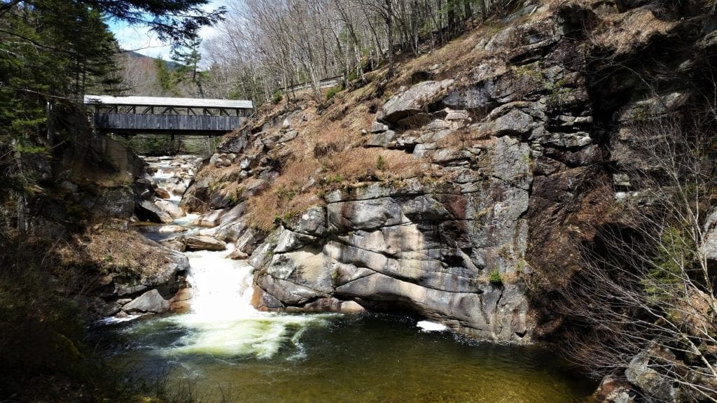
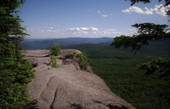
Table Rock
Walking up through the gorge, you’ll come to the large outcropping called Table Rock, which was created by the plunging waters of Flume Brook.
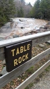
Table Rock is a section of Conway granite that is 500 feet long and 75 feet wide.
The stream bed widens here, too, over the broad expanse of flat granite, with the water passing over it in a gleaming, paper-thin sheet. (The rocks are slippery – please stay on the trail.)
A few hundred feet more of walking leads to the mouth of the gorge, and you step into a different world!
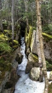
The Flume Trail
The Flume Trail is the major attraction of the gorge. Guests can choose to walk through just the Gorge or do a hiking loop through the area. It’s only a two mile round-trip hike, so it’s an easy, fun, family outdoor adventure.
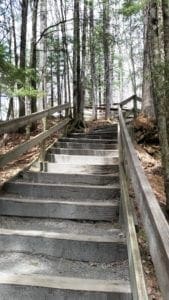
The walk includes uphill walking and lots of stairs, so do be prepared for that.
Because there are so many stairs, the path may be challenging for small children or the elderly. It’s definitely not stroller friendly, either – so have your littlest ones in a backpack or sling carrier
In season, there’s a bus available that brings visitors to the bottom of Flume Gorge. It will only save you about 1/2 mile of walking on flat terrain, though. There’s no way around the harder part of the climb.
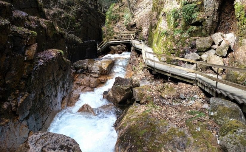
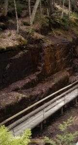
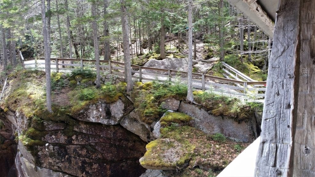
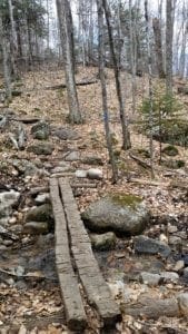
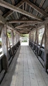
Once you’ve made your way about a mile up the dirt path (in whatever fashion), it turns into a boardwalk.
The boards are bolted into the rock to allow people to pass over the rushing water below, and have a closer look at the growth of flowers, ferns and mosses and the gorge walls themselves.
The boardwalk is inspected every year, and is very safe to walk on.
That said, the path near the falls can be slippery when wet, but the ridged wooden walkway helps prevent visitors from falling. I would also recommend wearing grippy shoes like trail runners or hikers.
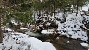
Inside the Flume, the light that filters down from the opening of the chasm seems softer, and the air is pleasantly damp. Even on a very hot day, it can be as much as 20 degrees cooler inside the gorge than at Table Rock.
The rock walls themselves trickle cool, clean water – and they also drip with life! Trees twist up from cracks and fissures in the granite, and the cliffs are covered with moss and other green plants.
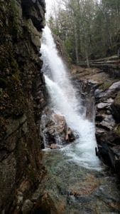
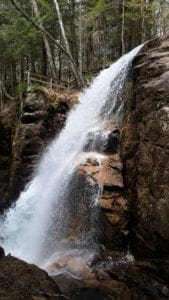
Avalanche Falls
Avalanche Falls is the highlight of the walk, and provides a cooling mist for overheated hikers 🙂
Located at the top of the gorge, Avalanche Falls is a 45-foot waterfall with an observation deck above, where you can listen to the water crashing on the rocks below.
The falling water echoes down the gorge— and creates an impressive roaring sound.
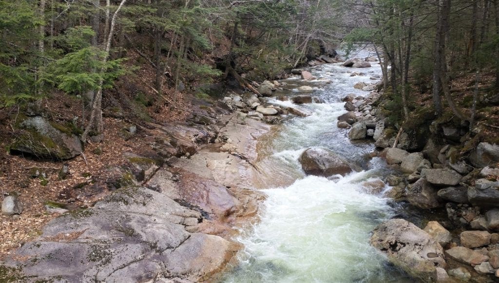
Liberty Gorge Cascade
Continuing on the Ridge Path back to the Visitor Center, you’ll see The Liberty Gorge Cascade, where the brook plunges down the narrow valley that precedes the Flume.
While it’s much smaller than Avalanche Falls, the Liberty Gorge Cascade is still quite beautiful.
After passing over the falls, you’ll come to an observation deck built into the side of the cliff.
It’s hard to see the falls from anywhere but the observation deck, so you’ll want to venture down to the deck for the best view.
The Pool and Sentinel Pine Bridge
Following the path around you’ll come to The Pool, a deep basin in the Pemigewasset River that was formed 14,000 years ago at the end of the Ice Age.
The Pool is 40 feet deep and 150 feet in diameter, and is surrounded by cliffs 130 feet high. A cascade continuously fills the pool, rushing over granite fragments that have fallen from the cliffs above.
The Pool is spanned by the Sentinel Pine Covered Bridge (the second covered bridge in the gorge), which affords a great view of the pool below.
For centuries, the Sentinel Pine tree stood on the high cliff above the Pool. It was one of the largest trees in the state, nearly 175 feet high, with a circumference of 16 feet.
The hurricane of September, 1938, uprooted the giant pine, but it was put to good use as the base of the bridge. Other trees uprooted in the same storm became the bridge’s superstructure and cover.
The Wolf Den
On the far side of the Sentinel Pine bridge you can crawl up into the Wolf Den, if you feel like scrambling a bit.
This is a narrow, one-way path that involves crawling on your hands and knees and squeezing through rocks.
When I was there in mid-May, the Wolf Den path was still filled with snow and impassable, but it would be a fun adventure for kids in the summertime.
Follow the path back up the hill to re-enter the Visitors Center for the end of your hike – or, explore a little bit more before you go.
OTHER FLUME GORGE ATTRACTIONS
Once you exit the Visitor’s Center, you can keep hiking (or biking!) on either of the paths below. Both trailheads are accessed through the upper parking lot.
There are also a few picnic tables scattered around the trailhead, if you want to take a snack break before your next hike.
Franconia Notch Bike Path
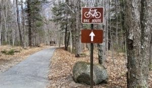
To cover the territory without looking through a windshield or putting miles on your hiking boots, the paved Franconia Notch Bike Path provides an eight-mile ride through the Notch with views all along the way.
A bike shop near the base of the Cannon Mountain Tramway offers rentals and repairs.
You can walk this too, if you like. Just keep your eye out for bikers.
Hike to Indian Head (Mount Pemiwagasset)
Mount Pemigewasset is frequently overlooked among the peaks of the Franconia Notch region, as it’s not quite as lofty as it’s neighbors.
The views from the top are just as spectacular, though.
From the top, granite slabs and ledges drop away nearly 1,500 feet into the floor of Franconia Notch.
This is quite a reward for the short (but steep) 1.5 mile hike to the summit from the Flume Gorge Visitors Center parking area.
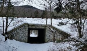
From the trailhead, the path crosses under the interstate via two tunnels before beginning its climb.
Keep an eye out for the blue trail blazes on rocks and trees to find your way.
The trail features stone stairs, bridges and numerous switchbacks, with a steady incline, roots and rocks most the way.
It also tends to get quite muddy after a rain.
If you are a beginner, or have children with you, I would allow up to 3-4 hours for the hike.
(There is another trail to reach the summit, marked with yellow blazes. The “yellow trail” starts from trailhead parking in Rte 3 near the Indian Head Resort. )
FLUME GORGE HOURS & ADMISSION FEES
Unlike many of the other New Hampshire State Parks, there is an admission fee to see the Flume Gorge.
Admission is $16 for adults (ages 13+); $14 for children (ages 6-12); children ages 5 and under are admitted free with paid adult.
Discovery Pass (Includes Cannon Mountain Aerial Tramway & Flume Gorge): Adults: $31.00, children (ages 6-12): $25.00.
*All rates and dates are subject to change.
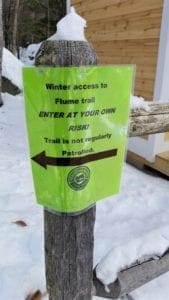
Because winters in New Hampshire can be brutal, the Flume Gorge is only open to the public from May-October.
It is conveniently located right off of I-93 North.
Operating hours are 8:30 am to 5:00 pm daily.
*Dates and times are weather permitting. For up to date hours, please call the park directly.
Are pets allowed at Flume Gorge and Visitor Center?
Pets are not permitted in the Flume Gorge and Visitor Center.
Pets are only permitted in Franconia Notch State Park in the designated dog walks in the Flume & Tramway parking lots.
Pets are prohibited from Echo Lake Beach, Lafayette Campground, on the Tram and in the Flume Gorge. See the NH State Parks Pets Policy for more information.
MORE ABOUT FLUME GORGE COVERED BRIDGES
Covered bridges have been part of America’s rural scenery since the early 1800’s and still draw tourists today.
New Hampshire has 66 covered bridges – and two of them are found in the Flume Gorge! (This map of New Hampshire’s covered bridges will help you find them all.)
In the past, covered bridges were often called “kissing bridges” because of the privacy they provided in an era when public displays of affection were frowned upon.
Whether you want to steal a kiss or just watch the tumbling water below, the covered bridges in the Flume Gorge are a wonderful, and historical, part of the landscape.
Each covered bridge is a unique construction in a one-of-a-kind, over-water setting, and each historic structure also has it’s own unique story.
SENTINEL PINE BRIDGE
Unlike the Flume Covered Bridge, the Sentinel Pine Bridge is pedestrians-only.
From certain angles as you walk along the Flume Trail, Sentinel Pine Bridge appears to be suspended in midair. It’s actually solidly anchored on opposing banks of the chasm.
The tall name-sake pine once stood near the rear of the pool as if it were a sentry on guard.
The great tree was 175 feet tall, 16 feet in diameter, and estimated to be 100 years old when it was blown over in the 1938 hurricane.
Workmen took a sixty foot piece of the fallen tree and placed it over the river forty feet above the water just north of the pool to form the base of the bridge.
Taking other trees that were also blown down, they made the footbridge over the pine to protect and preserve it.
The bridge is put together with wooden pegs. The shingles were handmade by John G. Welch and Old Joe Poloquin (also known as Indian Joe).
The Society for the Protection of New Hampshire Forests originally built this bridge in 1939 and maintained it, until it was transferred to the state in 1948. Sides were added to the bridge in 1984, for safety.
The Sentinel Pine Bridge is eligible for listing on the National Register of Historic Places.
THE FLUME COVERED BRIDGE
The Flume Covered Bridge was built across the scenic Pemigewasset River in 1866.
One of the oldest covered bridges in the state of New Hampshire, the bridge has been restored several times over the years.
Today, it remains open to traffic from tour buses and maintenance vehicles. It’s also open to people on foot.
The Flume Covered Bridge uses a Paddleford truss, a support structure created by builder Peter Paddleford in the 19th century, and used in many New England covered bridges.
The covered portion of the bridge is 50′ long. The bridge width is 20′-9″, and the roadway width is 11′-8″.
The bridge was originally covered with half-inch boards cut in about 30-inch lengths and put on like shingles. These were called “shakes” and served until a new covering was needed to stop leaks. Modern shingles replaced these shakes in 1951.
There has been some debate about where this bridge was actually built. Some say it was built, used elsewhere, and later moved to this spot.
Others believe it was built for its present location in 1871 when the Lincoln Turnpike Company (created by an act of the Legislature) gained the right to build the road from U.S. Route 3, to a point near the foot of the Flume.
The Flume Bridge is eligible for listing on the National Register of Historic Places.
BRIDGE SUPERSTITIONS
Bridges have often been subject to superstitions, perhaps because they are a literal passage between two places, and often symbolize movement from one stage of life to the next.
Here are a few:
- In parts of the world it’s considered unlucky to be the first person to cross a bridge, because the devil, (envious of the human ability to construct something so complicated), will take the soul of the first living creature to cross.
- Workers sometimes leave money in the plaster of a new bridge to protect it and ensure good luck. (A remnant of an earlier custom involving human sacrifice?)
- Some people touch the roof of their car, or spit, when driving under a bridge, to make sure it doesn’t collapse – though this seems both ineffective and unsanitary 🙂
- Smooching your beloved while passing through a covered “kissing bridge” is said to bring good luck.
- Sometimes known as “wishing bridges,” anyone with enough lung power to hold their breath the entire length of the covered bridge will get their wish.
Hiking-Related Bridge Tradition
The James River Footbridge is the longest footbridge on the Appalachian Trail, and the hikers who make that trek have a tradition about jumping off it.
This might not be one of the safer traditions – at least one hiker has died jumping off the bridge, and climbing it is now prohibited.
I hope you enjoyed this post, and got some ideas for your next family vacation. Leave a comment about your favorite experience at the Flume Gorge or Franconia Notch State Park!
If you’re looking for some travel pointers or ideas for your next adventure, check out my Travel Resources page.
If you have a question drop me a note and I’ll reply as soon as I can.
Thanks for stopping by – see you next time! LJ
To Get New Idratherwalk Posts
sent directly to your inbox (how convenient!) Click this Button
If you like this post, please share it!


LJ has spent much of her free time as a single Mom – and now as an empty-nester – hiking in the US and around the world. She shares lessons learned from adventures both local and in exotic locations, and tips on how to be active with asthma, plus travel, gear, and hike planning advice for parents hiking with kids and beginners of all ages. Read more on the About page.